Thursday, May 19, 2011

BALI PHOTO GALLERY

Balinese Dancer
 Ubud at Bali


Senggigi Beach
Kuta Beach
Garuda Wisnu Kencana (GOD WISNU)
Garuda Wisnu Kencana (GARUDA)

Pura Tanah Lot

BALI


Bali is the name of a province in Indonesia and also the name of the largest islands that are part of the province. In addition consists of the island of Bali, Bali provinceconsists of the islands smaller in the vicinity, namely the island of Nusa Penida, Nusa Lembongan Island, Nusa Ceningan Island and Serangan Island.
Bali lies between Java and Lombok Island. Denpasar is the capital of it's province, located in the south of the island. The majority of Balinese are Hindu. In the worldfamous Bali as a tourist destination with a unique variety of art-culture, especially for the Japanese and Australian tourists. Bali is also known as Island of the Gods and The Thousand Pura Island


Balinese Culture


Music
Balinese traditional music has similarities with traditional music in many other areas in Indonesia, for example in the use of the gamelan and various other percussionmusical instruments. Nevertheless, there are peculiarities in the technique of playingand his composition, for example in the form kecak, namely a form of singing thatsupposedly mimic monkeys. Similarly, a variety of gamelan are played even unique,for example Jegog gamelan, gamelan gong gede, gamelan xylophone, gamelan andgamelan Semar selunding Pegulingan. There is also music playing for ceremoniesNgaben Angklung and Bebonangan music played in a variety of other ceremonies.

Dance


Balinese dance expert I Made Bandem in the early 1980s never classify theseBalinese dances, among others, who belong to the guardian for example Berutuk,Sang Hyang Dedari, Rejang and Line Gede, bebali among others are Gambuh, Topeng Pajegan and Wayang Wong, whereas balih-balihan among others is the Legong,Parwa, Arja, Prembon and Joged and various other modern dance choreography.
One of the dances are very popular for tourists is the Kecak Dance. Around the1930s, Wayan Limbak worked with German painter Walter Spies to create thisdance based ontradition Sanghyang and parts of the story of Ramayana . WayanLimbak popularizing this dance while traveling the world with his troupe of Balinese dancers.


Balinese dance in general can be categorized into three groups, namely wali, the sacred art of dance performances, art bebali or dance performances for ceremonies and also for visitors and balih-balihan or the art of dance to entertainment the visitors.


Wednesday, May 18, 2011

PROBOLINGGO

CLICK HERE FOR THE PHOTO GALLERY


Geographical 
Probolinggo is one district which lies in East Java province in the position of 112'50 "- 113'30" east longitude (BT) and 7'40 "- 8'10 'south latitude (LS), with an area of 
​​about 169 616 , 65 Ha or + 1696.17 km2 (1.07% of total land and seas of East Java Province).
Probolinggo district bordering regions: 

- West       : Pasuruan
- The South: Lumajang and Malang 
-The East   : Situbondo and Jember
- North       : Madura Strait


Judging from its geographical Probolinggo district situated on the slopes of mountains stretching from west to east, is Mount Semeru, Argopuro, Lamongan and Tengger. In addition there are other mountains, that is Mount Bromo, Widodaren, lustrous, Gambir, Jombang, Cemoro Lawang, Malang and Batujajar. Viewed from a height is at 0-2500 m above sea level with an average temperature of 27'C - 30'C.

 Probolinggo district located around the equator causes the area of ​​climate change are two types each year, namely dry season and rainy season. For the dry season ranged in April until October with average rainfall per day + 29.5 mm rain, while the rainy season from October to April with average rainfall per day + 229 mm of rain. Relatively high rainfall occurred in December to March with average rainfall per day + 360 mm of rain. Among these there are two seasons transition season that is usually characterized by dry winds that blow fast enough from southeast to northwest direction is called "Gending Wind "
 In addition, Probolinggo district has several attractions namely:
 
Mount Bromo  (The Most Popular In My Opinion)
 Madakaripura Waterfall 
 Gili  Ketapang Island  with marine park 
 Bentar Beach
 Pekalen River Rafting
 Ranu Segaran and Hot Springs

 Jabung temple that reflects the glory of the past.


PROBOLINGGO PHOTO GALLERY

Bromo
Bromo Homestay
Madakaripura Waterfall
Bentar Beach
Bentar Beach
Jabung Temple
Rafting on Pekalen River

Monday, May 16, 2011

BANDUNG PHOTO GALLERY

Paris Van Java
Paris Van Java(outdoor)
Tangkuban Perahu
Cibaduyut (center shoes outlet in Bandung)
Sate Building


WONOSOBO PHOTO GALLERY

Wonosobo Downtown


Garuda Monument Infront of Alun Alun


Wonosobo Main Market


Wonosobo Alun Alun 


Wonosobo-Temanggung Border
Mie Ongklok and Beff Sate, the Typical Food of Wonosobo


DIENG


Please visit Dieng Photo Gallery HERE after you read this article


Dieng is a plateau in Central Java, who entered the district of Banjarnegara and Wonosobo regency. It lies to the west of Mount Sindoro complex and Sumbing. 

Dieng is an active volcanic area and it can be said is a giant volcano. Crater craters are often found there. The average altitude is about 2,000 m. above sea level. Dieng cool temperatures in winter approached, ranging from 15-20 ° C in the daytime and 10 ° C at night. In the dry season (July and August), air temperature can sometimes reach 0 ° C in the morning and bring frost by the locals who called the poison bun ("dew poison") because it causes damage to agricultural crops. 
The administration, including Dieng Dieng Kulon village, Subdistrict Batur, and Dieng Wetan Banjarnegara District, District Kejajar, Wonosobo regency. Until the 1990s this area was not reached by electricity and is one of the most remote regions in Central Java.


Etymology

Dieng name comes from the combination of two words Kawi language: "in" which means "place" or "mountain" and "Hyang" which means (God). Thus, Dieng mean mountain areas where the gods and goddesses residing. The name comes from the Sundanese Dieng as predicted in pre-Medang around the year 600 AD the area was under the influence of the Kingdom Galuh politics. 


Geology

Dieng Plateau is a plateau with volcanic activity below the surface, such as Yellowstone or the Tengger Highlands. Indeed he is a caldera in the surrounding mountains as the edges. There are many craters as the discharge gas, water vapor and various other volcanic material. The situation is very dangerous for the people who inhabit the region, as evidenced by the catastrophic gas explosion crater Sinila 1979. Not only poison gas, but also to possible earthquakes, mud eruptions, landslides and floods.
Apart from the crater, there are also volcanic lakes that contain water mixed with sulfur and thus have distinctive yellow-green color.
In biology, volcanic activity at Dieng interesting because it is found in hot waters near the crater of some species of thermophilic bacteria ("like it hot") that can be used to expose early life on Earth.

Craters
Here are the craters on DIENG:
Candradimuka
Sibanteng
Siglagah
Sikendang, potentially toxic gas
Sikidang
Sileri
Sinila, potentially toxic gas
Weigh, potentially toxic gas


Sibanteng Crater

Sibanteng located in the village of Dieng Kulon. This crater had erupted freatik two in January 2009 (15 / 1) [1], causing Dieng tourist areas to be closed several days to anticipate the occurrence of gas poisoning disaster. The eruption of the mud came up to 2km, Perhutani property damage in the surrounding forests, and causing landslides that block the White Kali, son Serayu River.
Previously Sibanteng Crater erupted in July 2003.

 Sikidang Crater

The crater is a crater in the DTD Sikidang the most popular visited by tourists because most easily achieved. This crater is famous for the gas discharge holes are always moving in a broad region. Because of frequent moves like a deer, then orang2 around the crater called Sikidang (fawn).


 Sileri Crater

Sileri is the most active crater and has erupted several times (note that there are 1944, 1964, 1984, and July 2003). At last freatik activity (26 September 2009) appeared three new craters valve accompanied by jets of material as high as 200 meters. [2]


 Sinila Crater

Sinila located in the village of Dieng Wetan. Sinila crater had erupted on the morning of 1979, [3] precisely February 20, 1979. The quake caused a resident ran out of the house, but then trapped gas out of the crater eruption triggered Sinila Weigh result. [4] A number of residents (149 people) and livestock killed off the carbon dioxide gas poisoning and spread to residential areas.

Peaks:
Prahu Mountain (2565 m)
Pakuwaja Mountain (2395 m)
Sikunir Mountain (2263 m), tourist attractions, close Sembungan
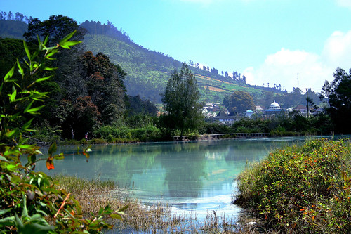
Lake volcanic
Lake Colour, with attractions nearby places persemadian
Cebon Lake, near the tourist village Sembungan
Telaga Merdada
Telaga Pengilon
Telaga dringo
Telaga Nila


Tourist Object


Several cultural and natural heritage has been used as a tourist attraction and is managed jointly by the two districts, namely Banjarnegara and Wonosobo. Here are some attractions in Dieng:

Lake: Telaga Warna, a lake that often creating shades of red, green, blue, white, and violet, Pengilon Lake, Lake Merdada.
Crater: Sikidang, Sileri, Sinila (explode and release toxic gas in 1979 with 149 victims of the soul),  Candradimuka Crater
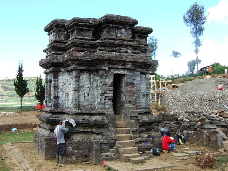
Complex of Hindu temples built in the 7th century, among others: Temple Gatotkaca, Candi Bima, Arjuna temple, Candi Semar, Sembadra Temple, Temple Heroine, Temple Setyaki, Gangsiran Aswatama, and Temple Dwarawati.
Caves: Cave Semar, Jaran Cave, Cave Wells. Located between Lake and Lake Pengilon color, often used as a place of spiritual though.
Jalatunda wells.
Dieng Volcanic Theater, theater to see movies about kegunungapian in Dieng.
Dieng Kailasa museum, store artifacts and provide information about the nature (geology, flora and fauna), the people Dieng (daily life, agriculture, beliefs, arts) and the archaeological heritage of Dieng. Having a theater to see the movie (currently about archaeological Dieng), an open stage on the roof of the museum, and restaurants.
Serayu River springs, often referred to as the Tuk Biomolukar (Tuk = spring). 


DIENG PHOTO GALLERY

Sikidang Crater
Bima Temple
Gatotkaca Temple
Telaga Warna(Warna Lake)
Telaga Pengilon(Pengilon Lake)
Dieng plateau Theater
Sileri Crater
Sibanteng Crater
Arjuna temple complex


Tuesday, May 10, 2011

BANDUNG


CLICK HERE FOR BANDUNG PHOTO GALLERYBANDUNG IN GENERAL                                                                                                                                                          
Bandung city (Municipality) is the capital of West Java province. The city was in ancient times was known as Parijs van Java (Dutch language) or "Paris of Java".Being situated in the highlands, Bandung was known as a place of cool temperate.This makes the city of Bandung as one tourist destination. While the existence of state universities and many private universities in Bandung make this city known as one student city in Indonesia. 

The flag used by the city of Bandung is based on the Decree of the Regional Representatives Council, while the Big City Bandung on June 8, 1953, No. 9938/53. 

Form of the flag are as listed in the above decision was dictum as follows: 

The flag adopted by the City of Bandung is a three field of horizontal lines, each in succession from top to bottom colored GREEN, YELLOW, and BLUE. 
Comparisons between the width and the lines under the letter 'a' sequence from top to bottom is 2:1:1. 
Comparison between different length and width was 7:5. 

History

Bandung is located at coordinates 107 ° E and 6 ° 55 'latitude. Bandung Area is 16,767 hectares. The city is geographically located in the middle of West Java province. Thus, Bandung has a strategic value to the surrounding areas. 

Bandung is situated at an altitude of ± 768 m above sea level on average (mean sea level). 
Areas north of the city of Bandung in general higher than the south. The average altitude in the north is ± 1050 asl, while in the south is ± 675 asl. Bandung is surrounded by mountains that create a kind of basin Bandung (Bandung Basin). 

Bandung fed two main rivers, the River Cikapundung and Citarum River and its tributaries, which generally flows to the south and meet in the Citarum River. 
With such conditions, the south of Bandung is very susceptible to flooding problems. 

Typical Food of Bandung
 

Bandung as one destination for culinary tourism. Among the famous food of Bandung were: 

Dumplings 
Batagor 
Lomie 
Mie Ceker Akung 
Elizabeth cendol 
Surabi 
Oncom 
Tempe Goreng 
Peuyeum Bandung Colenak (dicocol Delicious) 
Cireng (made ​​from sago with Various contents in it, Such as: cheese, oncom, meat,etc.)


WONOSOBO

CLICK HERE FOR WONOSOBO PHOTO GALLERY


A. DISTRICT WONOSOBO


Wonosobo regency which can be reached in about 3 hours by car from Yogyakarta.It has a population of about 769,000 people, who generally, as much as 80 percent, rely on living from agriculture. The main production plants are cultivated by farmers have ups and downs, ranging from potatoes that have been attempted since the 1980's until the start a lot of tobacco planted in the 1990s. Micro, small and medium enterprises (SMEs) are quite often found in Wonosobo, with a total of about 18,000.
The district is composed of 15 sub districts, 236 villages, and 29 Village has mountainous topography. Eastern (the border with County Waterford), there are two volcanoes: Mount Sindoro (3136 meters) and Mount Cleft (3371 feet). Northern Areasare part of the Dieng Plateau, with the peak of Mount Prahu (2565 meters). In the south, there Wadaslintang Reservoir.
Capital of Wonosobo regency was in the middle of the regency, which is the upstream region Serayu time. Wonosobo crossed by roads linking the province of Semarang,Purwokerto.


B. Wonosobo  Tourist Object 
 Tambi Agro Tourism 
Agro Tourism Tambi Sprawled on the slopes Sindoro wide, with a height of 1200-2000 m above sea level. The average air temperature of at least 15 º C and maximum temperature 24 º C. PT. Tambi manage the plantation 3 units located in Bedakah, Tanjungsari, Tambi village with an area of 829 hectares which is equipped tourist lodge facilities, fishing pond, tennis court, playground, gardens and tea factory .Visitor will be invited to tour through the tea garden path, exercise while enjoying views, also briefed about the agronomic, processing and marketing. For visitors who want to spend the night also provided a cottage with facilities that are satisfactory.


Gardu Pandang Tieng 
Prior to the Dieng Plateau, a moment we can unwind on the Substation Pandang Tieng, with an altitude of 1800 m above sea level, from above viewing post can enjoy beautiful views, and in the morning can also see the sunrise with golden light or by the term "Golden Sun Rise" in the morning and the trip can proceed to Dieng Plateau to see the sunrise, the second with a light silver (Silver Sunrise)
Telaga Menjer 
It is the largest natural lake in Wonosobo regency. Located at an altitude of 1300 meters above sea level, with an area of 70 ha and a depth of 45 meters. Maron Menjer Lake District village situated Garung Wonosobo district 12 km north of the town of Wonosobo.


                  Telaga Warna

This is one tourist attraction in the Dieng area Wonosobo named Telaga Warna. Telaga Warna having a high sulfur content can change from green, yellow or blue. visitors also can walk along the lake from below, because the manager provides a small balcony for the tourists.


 Kalianget Hot Spring


Kalianget Recreation Park is one of tourist objects owned Wonosobo regency. Thisrecreational park is just 3 km from downtown, precisely located at Jalan Dieng 3 orkilometers north of the town of Wonosobo.


Recreation Park Kalianget provides a natural hot spring baths, where the watercontains Sulfuric acid is high enough so efficacious to cure various skin diseases.Not only that, the Parks Recreation Kalianget also provide sports facilities to providefacilities such as tennis courts, football stadium, swimming pool, playground andfishing pond.

Travelers who visit the park recreation Kalianget, will get a relaxed atmosphere whiledoing sports activities. After doing sports tennis or swimming, visitors can rest whilebathing hot springs found there.

Kalianget Recreation Park is also one of the government program to protect thepotency of nature and become one of the regional assets. Owned natural resources in the form of hot water sources, topography, and an interesting view about the area is also surrounded by hills and green open space that is still natural.


Sikarim Waterfall

Has a height of 80 meters with a backdrop of towering hills and a lot of overgrown shrubs and rare plants. Located in the village district Mlandi Garung town 20 km north of Wonosobo.